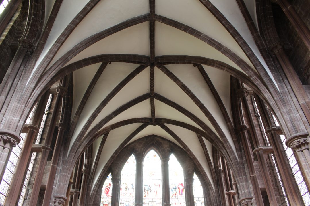
The principal problem in studying the geometry of medieval vaults is the availability of accurate measurements. Most of the existing surveys of English medieval vaulting were conducted using traditional analogue techniques, involving rods, plumbs lines and mathematical calculations. However, the scope of these methods was starkly limited. Whilst some vaults such as those in aisles or cloisters were low enough that the springing points could be accessed by a simple ladder, high vaults such as those in the central vessel of a church could only be studied using scaffolding. Even when measurements were obtainable, their accuracy was highly variable and their reliability is therefore uncertain.
Digital surveying methods offer many advantages over their analogue predecessors. Accessibility is greatly increased, as surveys can be conducted from ground level for vaults of any height without the requirement of ladders or scaffolding. Measurements are more accurate and provide a far higher density of information than traditional methods. Data collection is faster and the resulting digital models are far more flexible in their potential applications for future study. In the earliest stages of our research, we tested three different techniques for surveying medieval vaults digitally: laser scanning, photogrammetry and total station. Each of these techniques have their own specific advantages and disadvantages. By comparing and contrasting the differences between them, it was possible to identify which methods should be used for each particular purpose, allowing us to obtain the best possible data for conducting our research.
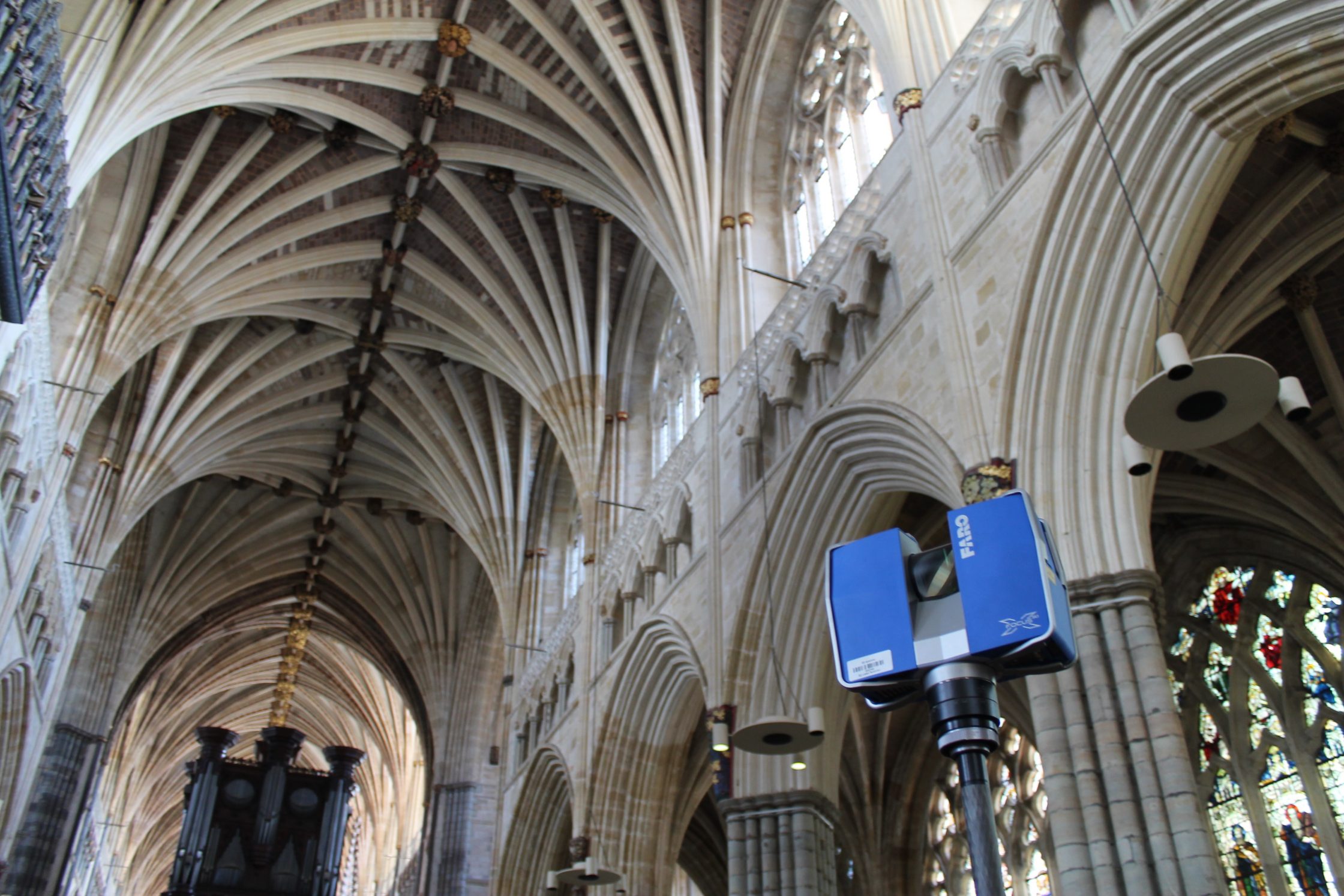
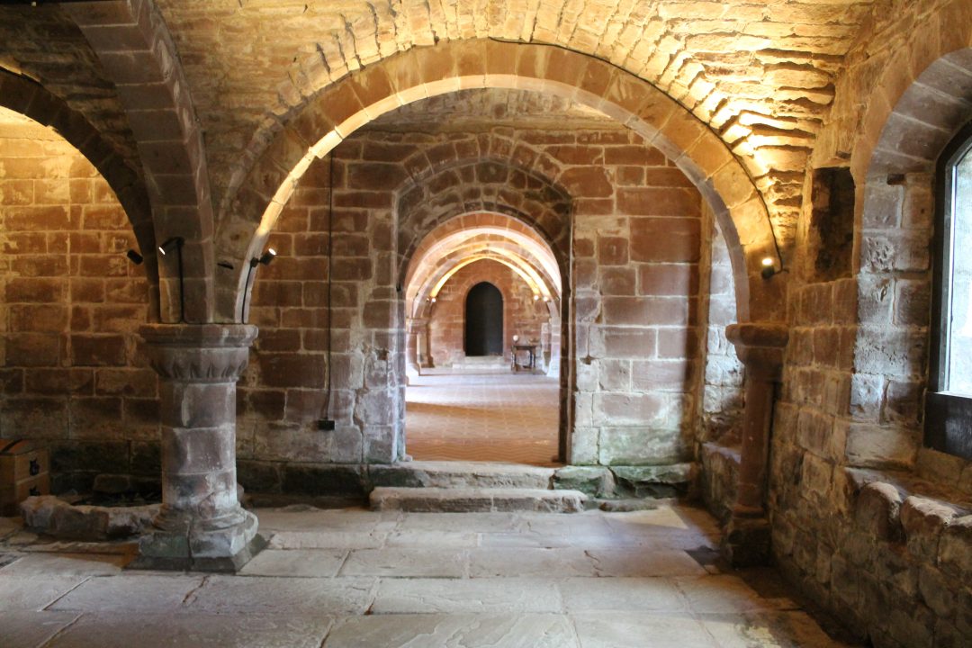
Laser Scanning
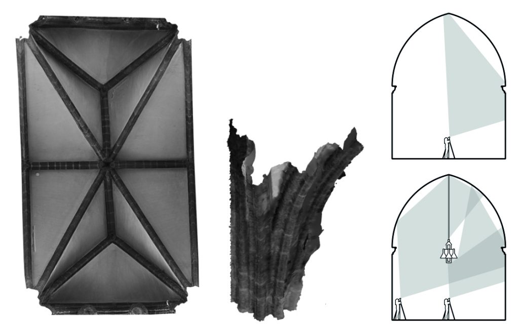
Laser scanning is a relatively recent surveying technique which offers high accuracy and efficiency. It is conducted using a tripod-mounted laser scanning station. Once activated, the scanner slowly rotates, emitting a series of laser pulses which record the distance between the point of emission and any solid surfaces that they hit. This technique records hundreds of thousands of points with each rotation, creating a dense cloud of reference points called a ‘point cloud model’. The vault’s appearance can also be recorded using a panoramic photograph stitched together by the scan station, with a specific colour being assigned to each individual point within the cloud. This produces a three-dimensional equivalent of the pixels in a conventional digital image, with each point possessing both a colour and a position within three-dimensional space.
After a scan is taken, the scanner is moved to a new location and the process is repeated. This intended to reduce the amount of ‘shadows’ in the survey data, gaps which appear in the point cloud when the line of sight of the surveying equipment is interrupted. By recording the interiors from different positions we can overlap the scans, maximising the area which can be reached by the laser.
When all required scans have been completed, they are then joined together digitally through a registration process using the laser scanner’s proprietary software. Reference points are located and then cross-referenced between different scans, allowing us to align them within three-dimensional space. Once the data has been tidied, a homogenised point cloud is created which can then be used to produce point cloud models, mesh models or orthophotos for each individual vault bay.
Through comparative testing, we found that the models produced using laser scanning were more accurate and complete than any of the other methods that we tried. Rather than focusing on specific parts of the building, the scanner captures all of the surface data in the building, allowing us to study the wider architectural context of the vault from floor to ceiling. Consequently, we found that laser scanning was the most effective method for conducting our research and began to use it as standard across all of our case study sites.
Total Station
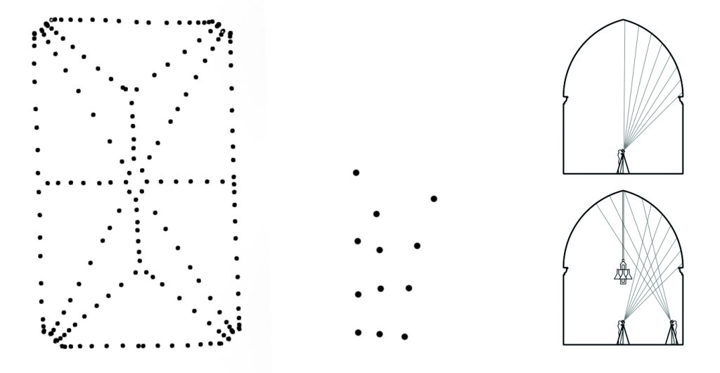
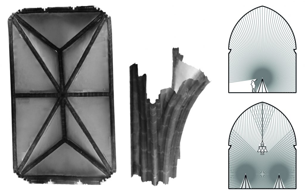
A total station scanner is a tripod-mounted piece of equipment which allows a surveyor to identify points in space using a laser guide or lens. At the press of a button, the total station emits a laser between to the defined point, automatically calculating its position in relation to the scanner. This process is then repeated several times to record a series of reference points relating the subject, in our case a series of points along the curve of the vault ribs. These could then be transferred into 3D modelling software and joined together into an arc, reproducing the geometry of the original rib.
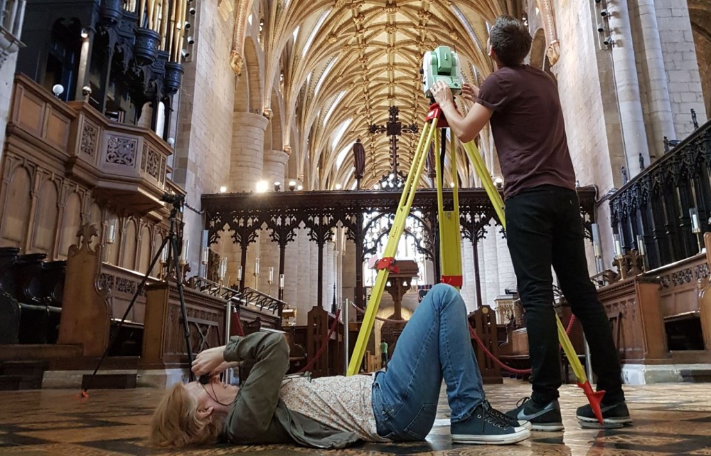
Total station scans can be quick to process, as files typically only include hundreds of points rather than the thousands or millions recorded by laser scanning. However, the surveying time can be far longer. In the Chapter House at Chester Cathedral it took us 95 minutes to record the rib curvatures of a single vault bay, compared to 13 minutes using laser scanning.
Whilst total station was not ultimately used for our project, it has been used extensively by other groups working on continental vaults. David Wendland has used total station to study the ribs in Late Gothic vaulting, producing precise models of the masonry joints which would be difficult to achieve using laser scanning or photogrammetry. As it is not fully automated, the method is particularly suited for investigating stonecutting techniques, allowing the user to make judgements with their own eyes during the recording process.
Photogrammetry
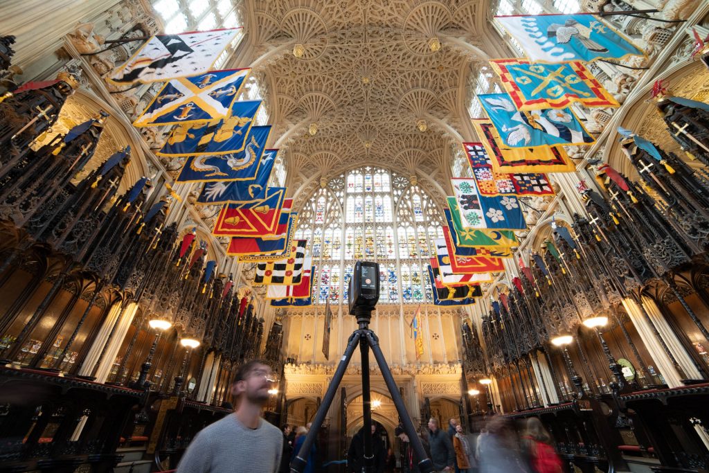
Photogrammetry is one of the most readily accessible means of producing 3D models, as it only requires a digital camera, tripod, measuring tape and the appropriate software. The technique involves taking many photographs of a single subject from multiple viewpoints, capturing the three-dimensional form of the object as thoroughly as possible. The photographs are then processed using software such as Agisoft Metashape, where the distances between points are calculated automatically based on the perspective of the images. These distances are then matched against each other to identify a series of points located in three-dimensional space, allowing us to create a ‘point cloud model’ of the building. Accurate scale is achieved by using scale bars or targets placed within the image, and can be checked using reference measurements taken on site.
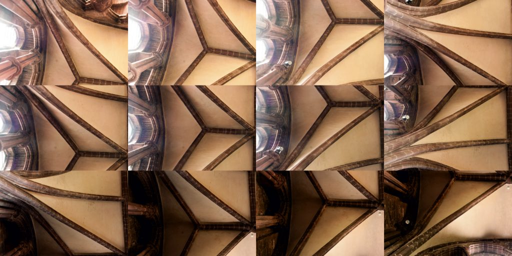
Photogrammetry allows for the creation of highly detailed models and the use of multiple viewpoints can help to minimise ‘shadows’. However, as vaults are located high inside buildings, it is not always possible to photograph them in sufficient detail from ground level and can be less reliable when taken at long distances.
Though we tested photogrammetry as a method for scanning several of our earlier sites, we did not choose to use it as our main method for recording data. However, we did make extensive use of it for our study of the tracing floor at Wells Cathedral. This large flat surface was used for the design of the vault in the nearby cloister, with a series of incised drawings conducted on a 1:1 scale. As the lines of the drawings are very thin and shallow, they were not detected by our laser scanner. However, photogrammetry allowed us to produce highly detailed images of the floor, enabling the geometry of the drawings to be measured accurately.
Further reading
- Buchanan, A., Hillson, J. and Webb, N., Digital Analysis of Vaults in English Medieval Architecture. New York and London: Routledge, 2021.
- Webb, N., Buchanan, A. and Peterson, J.R. (2016) ‘Modelling medieval vaults: Comparing digital surveying techniques to enhance our understanding of gothic architecture’, in Herneoja, A., Österlund, T. and Markkanen, P. (ed.) Complexity and Simplicity, 34th eCAADe Conference Proceedings. 2 vols. Brussels: eCAADe. 2, pp. 493–502.
- Webb, N. and Buchanan, A. (2017) ‘Tracing the Past: A Digital Analysis of Wells Cathedral Choir Aisle Vaults’, Digital Applications in Archaeology and Cultural Heritage, 4, pp. 19–27.
- Webb, N., Hillson, J., Peterson, JR, Buchanan, A. and Duffy, S. (2020). ‘Documentation and Analysis of a Medieval Tracing Floor Using Photogrammetry, Reflectance Transformation Imaging and Laser Scanning’, Proceedings of the 38th eCAADe Conference – Volume 2, TU Berlin, Berlin, Germany, 16-18 September 2020, pp. 209-218 (accompanying video)
13 Comments
[…] more about the history of the site Find out more about our digital surveying methods Find out more about vault design at […]
[…] out more about the history of the site Find out more about out digital surveying methods Find out more about vault design in Hotham’s Choir at Ely Find out more about vault […]
[…] Find out more about the history of the site Find out more about our digital surveying methods […]
[…] out more about the history of the site Find out more about our digital surveying methods Find out more about vault construction at Norton […]
[…] out more about the history of the site Find out more about our digital surveying methods Find out more about vault design at Ottery St […]
[…] out more about the history of the site Find out more about our digital surveying methods Find out more about vault design in St Hugh’s Choir at […]
[…] Find out more about the different methods which we use to conduct our surveys […]
[…] Find out more about the history of Exeter cathedral Find out more about our surveying methods […]
[…] Find out more about the history of the site Find out more about our digital surveying techniques […]
[…] Find out more about the history of the site Find out more about our digital surveying methods […]
[…] Find out more about the history of St Mary’s, Nantwich Find out more about our digital surveying methods […]
[…] Find out more about the history of the site Find out more about our digital surveying methods […]
[…] Find out more about the history of Wells Cathedral Find out more about our digital surveying methods […]